Results
We found 2 matching items.


Page 1 of 1
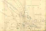
- Second Welland Canal - Book 3, Survey Map 12 - Village of Welland

 Survey map of the Second Welland Canal created by the Welland Canal Company showing the canal in the Village of Welland. Identified structures and features associated with the Canal include the towing path, the old canal, the aqueduct lock, the new aqueduct, the old aqueduct, Lock Tenders House, a waste …
 Survey map of the Second Welland Canal created by the Welland Canal Company showing the canal in the Village of Welland. Identified structures and features associated with the Canal include …Brock University Archives
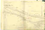
 - Second Welland Canal - Book 3, Survey Map 13 - Village of Welland - Merrittville and Crowland

 Survey map of the Second Welland Canal created by the Welland Canal Company showing the township of Crowland as well as the Village of Welland-Merritville. Identified structures associated with the Canal include Old Canal, old towing path, water way, bridge, culvert, covered drain, drain, and towing path. Surveyor measurements and …
 Survey map of the Second Welland Canal created by the Welland Canal Company showing the township of Crowland as well as the Village of Welland-Merritville. Identified structures associated with the …Brock University Archives
Page 1 of 1


