Results
We found 7 matching items.


Page 1 of 1
- Frances (1898)
 Official No.: 103941; 56x14x6 Owned by J. Robinson, Millerton N. B. Wrecked 13/09/00 Cape St. George P. E.I. ; Final Location: Cape St. George, Prince Edward Island, Canada, Wrecked
  Official No.: 103941; 56x14x6 Owned by J. Robinson, Millerton N. B. Wrecked 13/09/00 Cape St. George P. E.I. ; Final Location: Cape St. George, Prince Edward Island, Canada, WreckedMaritime History of the Great Lakes
 - St. Kilda (1898)
 Official No.: 103942; 65x18x4 Owned by J. B. Snowball, Chatham N. B. Tug.
  Official No.: 103942; 65x18x4 Owned by J. B. Snowball, Chatham N. B. Tug.Maritime History of the Great Lakes
 - F. R. Buell (Propeller), damaged, 20 Jun 1898

 Reason: damaged Remarks: Repaired
 Reason: damaged Remarks: RepairedMaritime History of the Great Lakes
 - Gazelle (Steamboat), machinery disabled, 9 Aug 1898

 Reason: machinery disabled Lives: nil Remarks: Repaired
 Reason: machinery disabled Lives: nil Remarks: RepairedMaritime History of the Great Lakes
 - Saturn
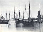
 Photograph of the Welland Canal below Lock One. SATURN is at centre of this photo. At left is CUBA. At right schooner-barge F.L. DANFORTH and steamer ERIN.
  Photograph of the Welland Canal below Lock One. SATURN is at centre of this photo. At left is CUBA. At right schooner-barge F.L. DANFORTH and steamer ERIN.Toronto Marine Historical Society
 - Lake Erie
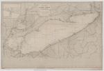
 Chart of Lake Erie includes references to a number of wrecks, including the approximate position of the CITY OF VENICE and LOCKWOOD.
  Chart of Lake Erie includes references to a number of wrecks, including the approximate position of the CITY OF VENICE and LOCKWOOD.Maritime History of the Great Lakes
 - Lake Erie: West End [1864, 1898]
 North America Lake Erie West End From the United States Coast Survey 1849 Soundings in feet ... Note. The depth of water varies, according as the Seasons are wet or dry, the maximum being from 2 to 3 ft. --inset-- Kingsville Harbour From a Canadian Government Survey 1895 Soundings in …
  North America Lake Erie West End From the United States Coast Survey 1849 Soundings in feet ... Note. The depth of water varies, according as the Seasons are wet or …Maritime History of the Great Lakes
Page 1 of 1


![Lake Erie: West End [1864, 1898] Lake Erie: West End [1864, 1898]](https://images.MaritimeHistoryoftheGreatLakes.ca/images/MHGL000122618t.jpg)
