Results
We found 2 matching items.


Page 1 of 1
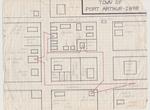
- Hand drawn map of Port Arthur -1898

 This map of Port Arthur in 1898 was drawn by Archibald McDougall to show where the telegraph lines ran at that date. The red lines indicate the telegraph lines. Mr. McDougall’s sister was the telegraph operator at the time, and the telegraph lines ran into the McDougall home where Miss …
 This map of Port Arthur in 1898 was drawn by Archibald McDougall to show where the telegraph lines ran at that date. The red lines indicate the telegraph lines. Mr. …Thunder Bay Public Library
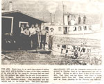
 - Newspaper clipping about 'The Ark', circa 1910.

 Black and white photograph of a newspaper article on 'The Ark.' The Ark was a cabin on a barge used by loggers. The Ark enabled loggers to stay out in the wilderness and keep putting logs into the river.
 Black and white photograph of a newspaper article on 'The Ark.' The Ark was a cabin on a barge used by loggers. The Ark enabled loggers to stay out in …Burk's Falls, Armour & Ryerson Union PL
Page 1 of 1


