Results
We found 4 matching items.


Page 1 of 1
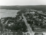
- Aerial Photograph of Main Street and Highway 11, Sundridge, circa 1960

 Black and white aerial photograph of Sundridge and Lake Bernard. In the middle is the Main Street and Highway 11.
 Black and white aerial photograph of Sundridge and Lake Bernard. In the middle is the Main Street and Highway 11.Sundridge - Strong Union PL
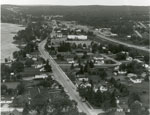
 - Aerial Photograph of Main Street and Highway 11, Sundridge, circa 1960

 Black and white aerial photograph of Sundridge Ontario during the 1960s. Lake Bernard is on the left of the photograph. In the middle of the image is the Main Street and Highway 11 is on the right side of the photograph.
 Black and white aerial photograph of Sundridge Ontario during the 1960s. Lake Bernard is on the left of the photograph. In the middle of the image is the Main Street …Sundridge - Strong Union PL
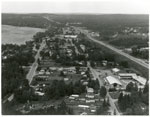
 - Aerial Photograph of Sundridge, circa 1960

 Black and white aerial photograph of Sundridge Ontario during the 1960s. A small portion of Lake Bernard can be seen in the upper left hand portion of the image. Hwy 11 can be seen on the right hand side of the photograph.
 Black and white aerial photograph of Sundridge Ontario during the 1960s. A small portion of Lake Bernard can be seen in the upper left hand portion of the image. Hwy …Sundridge - Strong Union PL
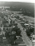
 - Aerial Photograph of Main Street and Highway 11, Sundridge, ON, circa 1960

 Black and white aerial photograph of Sundridge during the 1960s. Highway 11 is on the right side of the image, and the main street of Sundridge is the prominent road on the left side of the photograph.
 Black and white aerial photograph of Sundridge during the 1960s. Highway 11 is on the right side of the image, and the main street of Sundridge is the prominent road …Sundridge - Strong Union PL
Page 1 of 1


