Results


Page 1 of 1
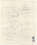
- Map of the Village of Scotland, 1894

 This item is a reproduction of an 1894 map depicting the village of Scotland in the Townships of Burford and Oakland, County of Brant. It was produced by Jones & Fairchild, Ontario Land Surveyors. This map is Zoomify enabled! Click on the map to zoom in and pan around so …
 This item is a reproduction of an 1894 map depicting the village of Scotland in the Townships of Burford and Oakland, County of Brant. It was produced by Jones & …County of Brant Public Library
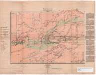
 - Seine River Sheet : Thunder Bay and Rainy River Districts
 Map housed at the Brodie Resource Library
  Map housed at the Brodie Resource LibraryThunder Bay Public Library
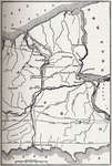
 - Map showing Course of the Ancient St. Lawrence and its Tributaries
 Illustration from J. B. Mansfield, ed., History of the Great Lakes. Volume I, Chicago: J. H. Beers & Co., 1899
  Illustration from J. B. Mansfield, ed., History of the Great Lakes. Volume I, Chicago: J. H. Beers & Co., 1899Maritime History of the Great Lakes
 - Map of Warren Water
 Illustration from J. B. Mansfield, ed., History of the Great Lakes. Volume I, Chicago: J. H. Beers & Co., 1899
  Illustration from J. B. Mansfield, ed., History of the Great Lakes. Volume I, Chicago: J. H. Beers & Co., 1899Maritime History of the Great Lakes
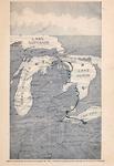
 - Map of the Early Lakes.
 Illustration from J. B. Mansfield, ed., History of the Great Lakes. Volume I, Chicago: J. H. Beers & Co., 1899
  Illustration from J. B. Mansfield, ed., History of the Great Lakes. Volume I, Chicago: J. H. Beers & Co., 1899Maritime History of the Great Lakes
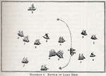
 - Battle of Lake Erie
 Illustration from J. B. Mansfield, ed., History of the Great Lakes. Volume I, Chicago: J. H. Beers & Co., 1899
  Illustration from J. B. Mansfield, ed., History of the Great Lakes. Volume I, Chicago: J. H. Beers & Co., 1899Maritime History of the Great Lakes
 - Battle of Lake Erie
 Illustration from J. B. Mansfield, ed., History of the Great Lakes. Volume I, Chicago: J. H. Beers & Co., 1899
  Illustration from J. B. Mansfield, ed., History of the Great Lakes. Volume I, Chicago: J. H. Beers & Co., 1899Maritime History of the Great Lakes
 - Battle of Lake Erie
 Illustration from J. B. Mansfield, ed., History of the Great Lakes. Volume I, Chicago: J. H. Beers & Co., 1899
  Illustration from J. B. Mansfield, ed., History of the Great Lakes. Volume I, Chicago: J. H. Beers & Co., 1899Maritime History of the Great Lakes
 - The Welland Canal, between Lake Ontario and Lake Erie
 Illustration from J. B. Mansfield, ed., History of the Great Lakes. Volume I, Chicago: J. H. Beers & Co., 1899
  Illustration from J. B. Mansfield, ed., History of the Great Lakes. Volume I, Chicago: J. H. Beers & Co., 1899Maritime History of the Great Lakes
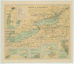
 - Tenth L. H. District
 Map of Lake Erie, Lake Ontario and upper St. Lawrence showing the different classes of lighthouses on both the Canadian and American shores. There are insets of the Detroit River, Maumee Bay, Sandusky Bay, Cleveland harbor, Erie harbor, Buffalo harbor
  Map of Lake Erie, Lake Ontario and upper St. Lawrence showing the different classes of lighthouses on both the Canadian and American shores. There are insets of the Detroit River, …Maritime History of the Great Lakes
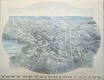
 - 1891 Town of Waterloo Map

 The printed date in the right hand corner of the second version of the map is incorrect. The map can be dated to ca. 1891 based on other copies and the presence of St. Louis Roman Catholic Church on Allen St.
 The printed date in the right hand corner of the second version of the map is incorrect. The map can be dated to ca. 1891 based on other copies and …Waterloo Public Library
 - Rice Lake Indian Reserve Sketch
 A sketch showing part of Rice Lake Indian Reserve, later Hiawatha Reserve no. 36. Part of Treaty 20.
  A sketch showing part of Rice Lake Indian Reserve, later Hiawatha Reserve no. 36. Part of Treaty 20.Kawartha Lakes Public Library
 - Bird's Eye View of Points Reached by the Detroit & Cleveland Steam Navigation Company

 Maritime History of the Great Lakes
Page 1 of 1

